"Or Atlantis never existed, or it was not at all what we thought it was "
Jacques-Yves Cousteau
This was the reason that legitimized the invasion of Egypt by the black pharaohs of the XXVth dynasty come from Napata.
The first rulers of Egypt with Kushite blood: Queen Ahmose-Nefertari and her son the pharaoh Amenhotep Ist in the beginning of the XVIIIth dynasty (New Kingdom).
Queen Ahmose-Nefertari (the widow of king Ahmose) was probably the daughter of king Kamose with a Kushite princess of Meroe (Makeda ? see the tomb of Maket in the funeral city of El Lahun (Fayum).

THE HUGE POWER OF KUSH :
THE RIVAL OF EGYPT IN THE NILE VALLEY
PLATON'S ATLANTIS
AS "THE ISLAND OF MEROE"

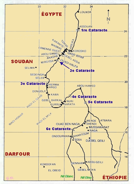
For more of two millenaries, Kushites were in rivalry with Egyptians for the domination of the Nile valley. Greeks called them Ethiopians, but the Land of Kush now pertains to the province of Butana district of Kerabas in Sudan.
Pharaohs of the XIIth dynasty (c. 1900 B.C.) had to built powerful fortresses at the level of the second cataract to protect their South frontier against the attacks of the bellicose Kushite kingdom of Kerma.
During the Second Intermediate Period (c. 1550 B.C.) Hyksos after invading Egypt tried to obtain an alliance with the Kerma ruler in order to strangle the frail Theban kingdom. Finally Kushites of Kerma were defeated by king Kamose who probably spoused a Kushite princess Makeda. Their daughter married king Ahmose and become the great queen Ahmose-Nefertari.
Finally king Thutmose III destroyed Kerma and established the Egyptian dominion on Nubia which remained administered by a viceroy vassal of Egypt until the reign of Ramses IX (1050 B.C.).
But circa 1000 B.C. a new Kushite kingdom emerged at the level of the 4th cataract. His capital was the city of Napata established close to the Kushite sacred mountain "Djebel Barkal", the house of god Amon. However there are indices that this dynasty of kings originated from Meroe, 200 km far to South.
This kingdom culminated when on 752 B.C. pharaohs of the XXVth dynasty originating from Napata conquered Egypt as far as Memphis and Sais. They reigned on both Nubia and Egypt. But in 671 B.C. they were expelled from Egypt by the Assyrian king Assurbanipal. However, they continued to reign on Upper Nubia from their residence of Napata.
In 591 B.C. pharaoh Psammetik II ordered a raid on the Kushite capital. The Egyptian armies which included a corps of Greek mercenaries reached Napata and burnt the temples of Djebel Barkal. Twenty years later, Kushites transferred their capital to Meroe far from the Egyptian power.
The floruit of the kingdom of Meroe spread from 568 B.C. to A.D. 350, but there are indices that the city already existed as early as the 8th century B.C. However until now only 30 % of the city were investigated by archaeologists.
According to ancient authors the territory of the kingdom of Meroe was encircled by three rivers : the Blue Nile on the South, the White Nile on the West and its affluent the Atbara River on the North-East. That is why it was named "the Island of Meroe". And according to Flavius Josephus (Antiquity of the Jews, II, 10) : “The city of Meroe was situated in a retired place, and was inhabited after the manner of an island, being encompassed with a strong wall, and having the rivers to guard them from their enemies, and having great dams between the wall and the rivers”. This very peculiar topography is the reason why we claim this site was the subject of the report of Plato describing the Atlantida island.
To know more about Meroe as the Atlas' kingdom, see our article : Plato’s atlantida nesos as the “Island of Meroe” : I. The reason why Egyptians were so friendly with the Greek Solon. II. Meroe the last royal city of Kush. III. Consistency of the “Island of Meroe” with Atlas’ kingdom.
And if you wish to travel over there and visit the archaeological sites with a guide : http://www.italtoursudan.com/en/